Long before vineyards traced the hillsides and canal towns lined the water, rivers and ice shaped a landscape that has always been more than scenery.
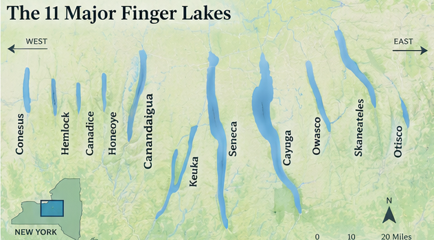
The Finger Lakes are eleven long, narrow lakes across west-central New York: from west to east, Conesus, Hemlock, Canadice, Honeoye, Canandaigua, Keuka, Seneca, Cayuga, Owasco, Skaneateles and Otisco. Together they form one of North America’s most recognizable inland landscapes, but the region’s history cannot be reduced to a postcard view. Ancient river valleys, repeated ice advances, living Haudenosaunee homelands, war and dispossession, canals, farms, reform movements, industry and generations of community life all meet here. The lakes have carried food, people, commerce, ideas and memory. Their slopes helped shape agriculture and winegrowing; their outlets powered mills; their towns became gathering places for movements that changed the nation. This overview follows that layered story without pretending it is finished. The Haudenosaunee nations whose ancestors lived here before European settlement remain sovereign peoples today, and the lakes continue to be watersheds, drinking-water sources and homes—not simply destinations. Understanding that depth makes every modern visit more meaningful.
A simplified locator map of the 11 major Finger Lakes, arranged from Conesus Lake in the west to Otisco Lake in the east.
01
A landscape carved over time
How Were the Finger Lakes Formed?
The lakes occupy valleys that began as north-flowing river systems cut into layers of sedimentary rock. Their modern shape came later, through repeated Pleistocene glaciations rather than one simple pass of a single glacier. Ice sheets advanced and retreated across New York many times. As thick ice moved along the existing valleys, rock fragments frozen into its base scoured the floors and walls. The ice widened the valleys, straightened parts of them and overdeepened the largest basins far below their former river channels.
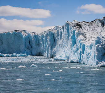
A modern glacier offers a visual sense of the immense power of moving ice. The continental ice sheets that shaped New York were broader, thicker and covered the entire region.
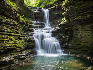
Gorges, waterfalls and steep-sided valleys are among the most visible features left by the region’s glacial history.
When the last major ice retreated north roughly 10,000 to 11,000 years ago, it left a complicated landscape of till, gravel, sand and other sediment. Moraines and deposits redirected drainage in different places; meltwater also cut side valleys and helped create the steep gorges now associated with Ithaca, Watkins Glen and other lake communities. Water collected in the overdeepened troughs, producing the long, parallel lakes visible today. Sediment did not form one universal northern dam; each basin inherited its own outlets, deposits and drainage changes.
The result is not eleven identical basins. Honeoye is only about 30 feet deep, while Seneca reaches about 618 feet. Cayuga and Seneca rank among the deepest lakes in North America, and their bottoms lie below sea level even though their surfaces sit hundreds of feet above it. This extreme relief affects water temperature, circulation, fisheries and nearby agriculture. The hills, gorges and lake-influenced climate visitors experience are connected parts of the same long geological story.
02
Living nations, enduring homelands
Haudenosaunee Homelands Before European Settlement
The Finger Lakes lie within the homelands of the Haudenosaunee Confederacy, sometimes called the Iroquois Confederacy in older English-language sources. The Confederacy joined distinct nations through the Great Law of Peace while preserving each nation’s identity, governance and territory. In the central and western Finger Lakes, Seneca and Cayuga communities held extensive lands; Onondaga territory centered farther east, around the eastern and central part of the region. Nearby Mohawk and Oneida nations, and later the Tuscarora, were connected through the Confederacy and its diplomatic world.
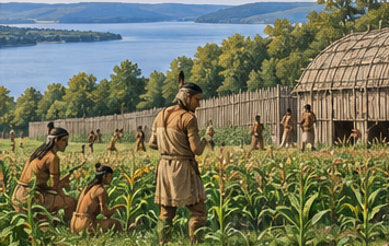
Editorial illustration of agricultural life in a Haudenosaunee community. The Finger Lakes remain part of the ancestral and living homelands of the Haudenosaunee Confederacy.
Haudenosaunee communities were not scattered camps in an untouched wilderness. They built substantial towns of bark longhouses, cultivated large fields of corn, beans and squash, managed orchards, hunted, fished and moved along sophisticated networks of trails and waterways. Women held responsibilities for land and agriculture and selected clan leaders. Trade and diplomacy connected communities across the Northeast and Great Lakes. Villages could shift location as fields and resources changed, but homeland, kinship and political relationships endured.
European epidemics, trade rivalries, missionary activity and colonial wars brought upheaval before the American Revolution. Even so, Haudenosaunee nations remained powerful. During the Revolution, leaders and communities made different choices; the conflict fractured the Confederacy’s unity without erasing its people or government. After the war, New York State and speculators pursued Haudenosaunee land through contested treaties and transactions.
Today, Haudenosaunee nations are living sovereign nations, not a vanished chapter. Their citizens sustain languages, ceremonies, governments, arts, agriculture and relationships to these lands. A responsible regional history begins with that continuity and recognizes that modern visitors are traveling through an Indigenous homeland.
03
Revolution and destruction
The Revolutionary War and the Sullivan–Clinton Campaign
The American Revolution became a brutal civil and frontier war in Haudenosaunee country. Some Haudenosaunee nations and communities allied with Britain, some supported the Americans, and others tried to remain neutral. Raids by Loyalist and Indigenous forces struck frontier settlements in New York and Pennsylvania; American attacks struck Haudenosaunee communities. These choices unfolded under pressure and divided families as well as the Confederacy.
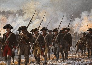
In 1779, George Washington ordered a large expedition intended to break the power and food supply of nations allied with Britain. Major General John Sullivan advanced north from Pennsylvania while Brigadier General James Clinton came south from the Mohawk Valley. After joining forces, their troops moved through the Finger Lakes and Genesee country. They burned Cayuga and Seneca towns, homes and stored crops; cut down or destroyed orchards; and ruined fields at harvest time. Newtown, near present-day Elmira, was the campaign’s principal battle, but destruction of civilian communities was its defining result.
Editorial illustration of Continental troops during the 1779 Sullivan–Clinton Campaign. The campaign destroyed Haudenosaunee towns, crops, orchards and food supplies across the region.
Thousands of Haudenosaunee people were displaced and faced hunger, exposure and disease. Many sought refuge near British posts. The campaign did not end the war on the frontier, but it devastated homelands and intensified later land loss. In the decades after independence, settlement expanded through state treaties, land cessions, speculation and the distribution of military tracts—processes inseparable from dispossession. Describing this simply as land being “opened for settlement” hides the people driven from it. The campaign’s routes and markers remain visible, but the fullest understanding comes from Haudenosaunee voices and from recognizing survival alongside loss.
04
Waterways and working landscapes
Canals, Farms, Vineyards and 19th-Century Growth
After the Revolution, roads, land companies and military land grants accelerated non-Native settlement. Farms spread across the uplands and valley floors, producing wheat, fruit, dairy goods and livestock for local use and distant markets. Lake outlets powered mills, and small landings became villages. The same hills that made overland travel difficult helped concentrate people and commerce along water routes.
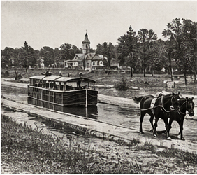
The Erie Canal, completed in 1825, changed the scale of those connections. It ran north of the principal lakes, but feeder and lateral canals tied the interior directly to the statewide system. Between 1826 and 1836, New York built the Cayuga–Seneca, Chemung and Crooked Lake canals, among others. Boats moved farm products, lumber, coal, manufactured goods and passengers; canal corridors also carried newspapers, religious movements, political organizing and new residents. Railroads later surpassed many smaller canals, yet the Erie and Cayuga–Seneca waterways continued to shape communities, industry and recreation.
Editorial illustration of canal-era transportation. Canal connections helped move agricultural products, manufactured goods and travelers between Finger Lakes communities and larger markets.
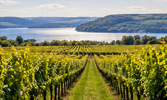
The deep lakes help moderate nearby temperatures, creating favorable conditions for vineyards and extending the grape-growing season.
Agriculture adapted to the region’s varied soils and climate. Orchards, nurseries and vineyards became increasingly important during the nineteenth century. The steep slopes near Keuka, Seneca and Cayuga offered air drainage, while large, deep lakes moderated temperature swings near their shores. Commercial grape growing and winemaking developed early around Keuka Lake and expanded elsewhere. Native and hybrid grapes dominated much of the early industry; later research, changing laws and new generations of growers helped establish the vinifera-based wine region visitors know today.
Growth carried costs. Forests were cleared, wetlands drained and industries polluted waterways. New transportation created opportunity while inequality persisted. The nineteenth-century Finger Lakes were a connected working region built on land whose ownership had been violently transformed.
05
Ideas, invention and change
Reform, Industry and the Modern Finger Lakes
The Finger Lakes became a major landscape of nineteenth-century reform. Religious ferment, abolitionist organizing and expanding print and transportation networks connected people across central New York. In Seneca Falls, roughly 300 women and men gathered at Wesleyan Chapel on July 19 and 20, 1848, for the first convention called specifically to discuss women’s rights. The Declaration of Sentiments challenged laws and customs that denied women equality and helped set a long movement in motion.
Auburn became another center of national consequence. Abolitionist networks included free Black residents, religious communities and white allies. Harriet Tubman moved her family from Canada to the Auburn area in 1859 and made her home there, continuing her work for freedom, community and human dignity until her death in 1913. The Seward family’s public life and antislavery connections further tied Auburn to national politics.
Industry grew beside reform. Salt production transformed Syracuse; mills, toolmaking, glass, ceramics and other manufacturing expanded in canal and railroad towns. Institutions such as Cornell University, founded in Ithaca in 1865, and state agricultural research in Geneva connected regional farms to scientific change. Tourism developed around lakes, gorges, steamboats, summer communities and scenic rail journeys.
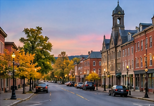
Historic main streets remain at the center of many Finger Lakes communities, connecting the region’s past with present-day shops, restaurants, museums and attractions.
In the twentieth and twenty-first centuries, manufacturing changed, the wine industry reinvented itself and conservation became urgent. Parks protected gorges and shorelines; communities began restoring polluted waters and canal corridors. Today farms, colleges, small cities, sovereign Native nations, technology, tourism and working waterfronts stand side by side. The modern region is the latest layer of a landscape still being cared for.
West to east
A Quick Guide to the 11 Finger Lakes
Figures are rounded from New York State Department of Environmental Conservation lake profiles. Dimensions help show how different the basins are; they are not a substitute for current navigation or safety information.
01
Conesus Lake
8 miles long · 66 feet deep
The westernmost Finger Lake combines active shoreline communities with broad shallows at its north and south ends. Its warmwater fishery and public launches make it a familiar recreation lake, while nearby Geneseo and Livonia connect it to the Genesee Valley. Conesus shows how each lake developed a distinct relationship between water, farms, villages and modern lake life.
02
Hemlock Lake
7 miles long · 91 feet deep
Hemlock is one of the region’s quietest lakes, with wooded slopes and very little shoreline development. Together with neighboring Canadice, it supplies drinking water to Rochester and is protected by watershed lands. Limited motors and restrained access give it a notably wild character—a reminder that the Finger Lakes are working watersheds as well as destinations.
03
Canadice Lake
3 miles long · 95 feet deep
Smallest of the eleven, Canadice is narrow, steep-sided and almost entirely undeveloped. Its protected watershed and simple access favor paddling, fishing and close observation rather than busy resort activity. At only about three miles long, it proves that the Finger Lakes identity is not limited to the large wine-country lakes; scale and character vary dramatically from basin to basin.
04
Honeoye Lake
4.5 miles long · 30 feet deep
Honeoye is the shallowest of the eleven and warms more quickly than its deeper neighbors. Rooted vegetation and productive shallows shape its ecology and recreation. The village and surrounding hills give the lake an intimate, lived-in quality. Its compact basin is a useful contrast to Seneca and Cayuga, where great depth creates a very different water environment.
05
Canandaigua Lake
15.5 miles long · 276 feet deep
Canandaigua stretches from the city of the same name toward the steep Bristol Hills near its southern end. The lake’s clear water, deep basin and long agricultural history support boating, communities and vineyards. Its name comes through Haudenosaunee language and place history; modern tourism should not obscure that the lake remains within an Indigenous homeland with enduring cultural meaning.
06
Keuka Lake
19.6 miles long · 183 feet deep
Keuka is instantly recognizable for its Y shape, with Penn Yan and Branchport at the northern arms and Hammondsport at the southern end. Its unusual branching basin, vineyard slopes and early commercial wine history distinguish it from the straighter lakes. The Keuka Lake Outlet also provided waterpower and a transportation connection east toward Seneca Lake.
07
Seneca Lake
38 miles long · 618 feet deep
Seneca has the greatest volume and depth of the eleven Finger Lakes. Geneva anchors its north end and Watkins Glen its south, while vineyard country occupies both shores. The enormous, cold basin influences nearby temperatures and supports a renowned wine landscape. Seneca is also central to Seneca Nation history and to the destructive route of the 1779 Sullivan–Clinton Campaign.
08
Cayuga Lake
38 miles long · 435 feet deep
Cayuga is the longest Finger Lake in New York State’s measurements, stretching north from Ithaca toward the wetlands and canal country near Montezuma. Its watershed is the largest of the eleven. Gorges, farms, colleges, vineyards and historic communities surround it, but the name first points to the Cayuga Nation, whose homeland and living identity remain inseparable from the lake.
09
Owasco Lake
11.1 miles long · 177 feet deep
Owasco lies directly south of Auburn, linking a compact lake landscape with one of the region’s most important historic cities. Tributaries drain a relatively large watershed into the lake, making land stewardship especially consequential for water quality. Auburn’s abolition, reform and industrial history—including Harriet Tubman’s life in freedom—adds a powerful human story to the lake’s setting.
10
Skaneateles Lake
16 miles long · 300 feet deep
Long, deep and notably clear, Skaneateles supplies unfiltered drinking water to Syracuse and other communities. The village at its northern end became a prosperous lakeside and canal-era community, while the quieter southern reaches feel markedly rural. Its high elevation and clean water reinforce the variety among the eleven lakes—and the responsibility that comes with depending on them.
11
Otisco Lake
5.4 miles long · 76 feet deep
Otisco is the easternmost Finger Lake and the only one divided into two noticeably different basins by a causeway. Its main northern basin is deeper and clearer; the smaller southern water is shallow and more turbid. Close to Syracuse yet distinctly rural, Otisco completes the west-to-east chain and demonstrates how human modifications now mingle with glacial geography.
06
Name, shape and story
Why Are They Called the Finger Lakes?
The modern English name describes the lakes on a map: long, slim, roughly parallel waters reaching south from Lake Ontario like fingers. Individual lakes carry much older names—many derived from Haudenosaunee languages and filtered through English spelling. Those names point to distinct places, nations and meanings rather than one uniform group.
A widely repeated regional legend says that a creator placed a hand upon the land, leaving impressions that filled with water. It is regional folklore, not an authenticated Haudenosaunee story unless a specific Haudenosaunee source identifies it. Popular retellings too often detach Indigenous-sounding stories from a named nation, language or storyteller.
Science gives a different explanation: pre-existing river valleys were widened and deepened during repeated glaciations, then filled as ice retreated and drainage changed. Metaphor and geologic process can coexist, but folklore should not replace geology—or speak for living Indigenous nations.
Authoritative starting points
Sources and Further Reading
This overview synthesizes resources from scientific, Indigenous, federal and New York State institutions. Follow the source organizations for deeper context.
Follow the landscape into its present-day vineyards, communities, historic sites and lakeside stays. Confirm hours and access directly as you build your route.